Nova Scotia GIS Maps: Never Get Lost Again
It’s that ridiculous, sticky-humid type of heat that has your shirt soaked in 15 minutes. Both mosquitoes and deerflies are swarmed around us, zooming in for bites. We’ve wandered through forest deadfall and thick brush full of thorny plants that tear your legs as you trudge through. And now, I realize, we’ve taken our first steps into a full-on marsh. After hours of this, Deb has nearly had it: “We’re lost, aren’t we?”
“Nooooo….” I say, holding my phone where she can’t see it and waiting for Google Maps to load. Damn, no signal. I remember that day well – it was a frustrating one. And it’ll never happen to me again.
For those in the know about the power of GIS maps combined with navigation apps, just roll your eyes and move on. But if you’re new to the topic, wow, this is a game-changer for anyone who loves to explore.
What Are GIS Maps?
Geographic Information Systems (GIS) maps are digital maps that capture, store, analyze, and display geographical data. Unlike traditional maps, GIS maps are dynamic and interactive. GIS maps are georeferenced – they align to real-world latitude and longitude coordinates. This alignment allows you to precisely pinpoint map locations and to layer various types of data such as property boundaries, topography, forestry characteristics, and a hundred other things. GIS maps are used by professionals in forestry, surveying, urban planning, and environmental monitoring. It was my connection with foresters and surveyors that got me chasing this one down – thanks fellas!
How GIS Maps Work
I could list the hundreds of data layers available, but let’s focus on those relevant to … buying land in Nova Scotia. First and foremost, the imagery – GIS maps provide some of the most detailed aerial and satellite photography available, period. You can see this in sites like Viewpoint and RemaxNova – look for “GIS” related options in the map layers. The difference between GIS imagery and Google Maps is often very significant.
With the photography as your base layer, the next most important layer for landbuyers and owners is property boundaries. If you’re navigating a 100-acre lot, it’s kind of nice to know when you’re stepping onto the land of a neighbour, especially that guy who loves to drink a lot and go hunting.
And it’s really as simple as that. I also use the forestry characteristics, and you can find layers for wildlife characteristics (such as locating habitats of rare or endangered species), but for the most part, you just want to know where you are in relation to the specific Nova Scotia property you’re exploring.
But GIS maps are only half the equation. Having a nicely georeferenced PDF of a 100-acre Nova Scotia parcel of land is only useful if you’ve got a tool to pinpoint YOU on that map.
Integration of GIS Maps with Navigation Apps
You want to have that GIS map – your georeferenced PDF file – loaded into a navigation app with offline navigation capabilities. I use Avenza Maps, and it’s been great to me so I haven’t needed to find any alternatives (I’m sure there are many). I’ll go into Avenza some more later in this post. Let’s get into how this stuff works…
GPS, or Global Positioning System, is a satellite-based navigation system that provides location information anywhere on Earth. GPS works by using a network of satellites that orbit the Earth. When you use an app like Avenza Maps, your smartphone receives signals from multiple satellites to calculate your exact position.
Your smartphone (with the right map and the right app) can connect to these GPS satellites to determine your location. Since the GPS signal is free and available worldwide, it allows your device to track your position without the need for cellular data or Wi-Fi. This is the game-changer I referred to earlier. With a bit of planning, no matter how remote you are and how spotty or non-existent the cellular coverage is, you need never get lost again.
Making the Complexity of GIS Maps Very Simple
This stuff can get pretty gnarly. The tools for viewing and outputting GIS maps are incredibly powerful, but not for the average user. Finding the right layers you want (such as Nova Scotia’s property boundaries) is tricky too. After kicking around at it for some time, I’m pleased to say I’ve got it down – at least as far as the basics that cover what I need, which is a highly detailed satellite image of the land I want to see, with a layer on top showing the property boundaries as they are registered in the Nova Scotia Property Online Registry.
So let’s make it simple. You need an app. You need a map. And once you connect the two you’re in navigation nirvana.
Step 1: Download Avenza Maps
Available for iOS and Android, this navigation app has everything I need, and more. You can use it for free with a limited number of active maps (three). Sure, over time you’re going to want to use more than three maps, but how many will you actively use at a time? The answer is usually one. When you reach your limit, simply delete a map you’re not using and add a new one. You can swap maps in and out endlessly.
Step 2: Download a Map
You can find maps by searching in the Avenza store in the app. Many are free. There’s a great map of Cape Breton Highlands National Park for example. Here’s a sample if you want to try one out – it’s a georeferenced GIS map for Kejimkujik National Park (the Park boundaries are not exact – I drew them in roughly as I could see them). I’ll write more about how to obtain GIS maps with property boundaries from the Nova Scotia Property Online Registry a bit further on, but here is an example of a GIS Map of a 100-acre lot in Cape Breton that has the property boundaries highlighted.
Step 3: Load your Map in Avenza
The Avenza interface is pretty intuitive. Click on “My Maps” and you’ll see a large orange + symbol in the lower right. Click that to add a map. Among the options you’ll see “Download or import a map”. On the next screen you’ll see several options for obtaining maps.
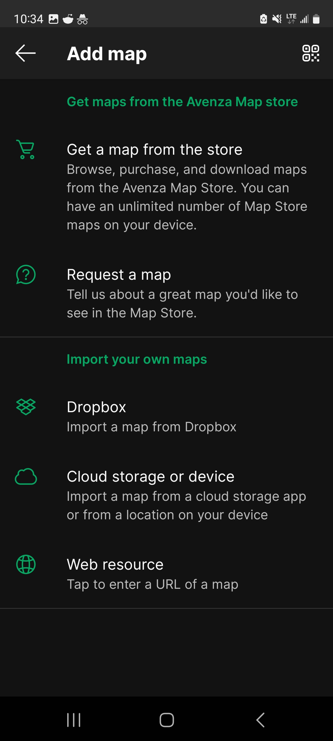
I keep it simple – I always store my GIS maps in a folder on my Google Drive. So I just need to click “Cloud storage or device” and then I can navigate in my Google Drive to that folder and select the map to load. That’s it! Once the map loads, you’re ready to navigate.
Navigating your GIS Map in Avenza Maps
If you are in the vicinity of the map you loaded, you should have no trouble seeing a blue dot that represents your location. If you’re out of range (e.g. driving toward the location), you’ll need to get closer. Now, there are a wide range of options, settings, and calibration methods for an app like Avenza Maps. I’m no expert in these and I’m sure you can learn a lot from the software’s documentation. But here’s the thing – I haven’t needed to adjust or reset a single thing – it has always worked automatically and perfectly for me.
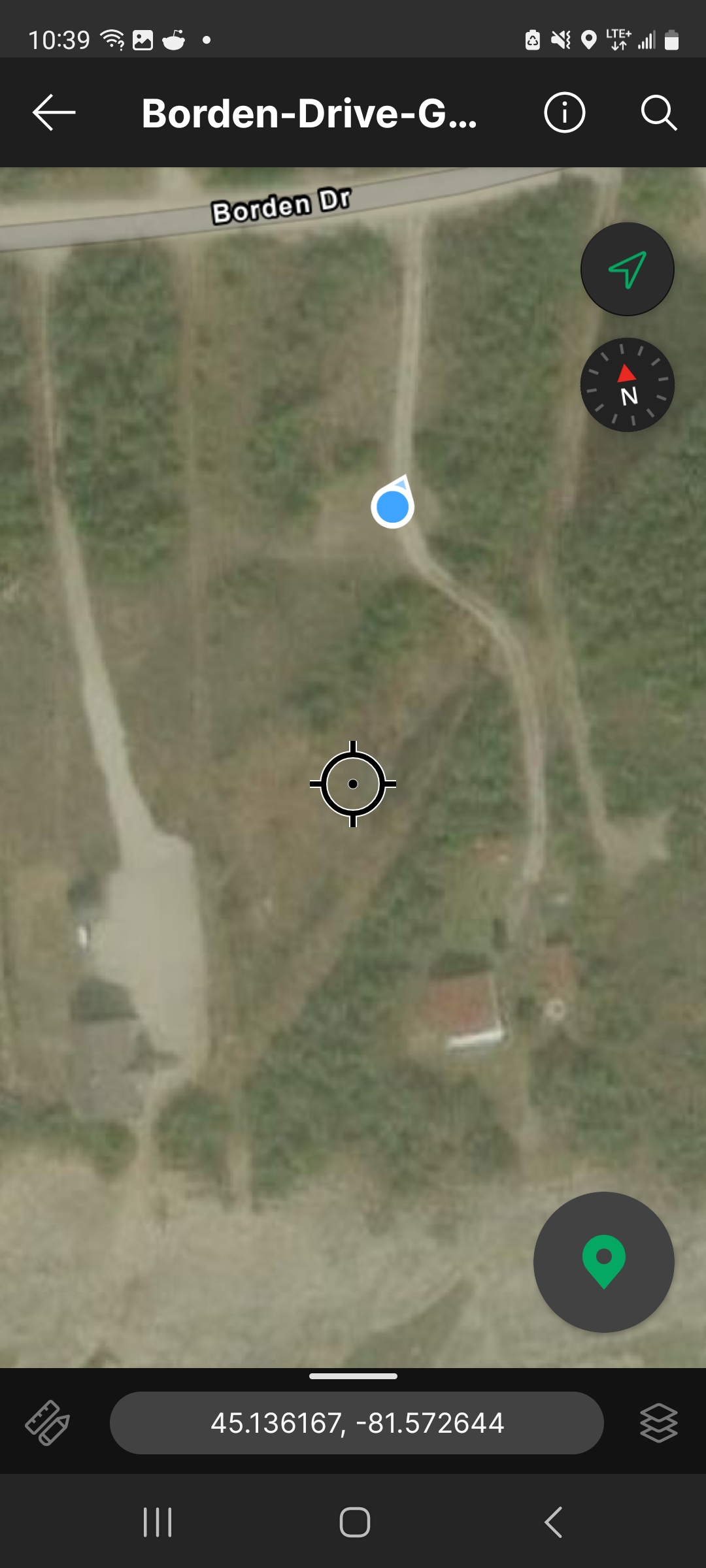
(Here’s a screenshot of me – the blue dot – walking up the driveway of my cottage. Note that the satellite imagery is foggy here. Normally it’s crystal clear but you may sometimes be surprised to see fog or snow in the image that can limit visibility.)
Just one note of caution for a first-time user. When you see your location on the map (showing as a blue circle with a white outline, you’ll also notice an arrow pointing from it. You might naturally assume it’s pointing in the direction you’re facing, but my experience is it’s not really the case. I find I’m better off focusing more on the circle rather than the arrow – you’ll see very quickly which direction you’re headed once you start moving. The app is remarkably precise at monitoring your location.
How to get GIS maps for Nova Scotia
Finding what you’re specifically looking for – say a specific property ID (PID), along with the property boundaries as defined in the Nova Scotia Property Online Registry, can be a frustrating search. When you think you’ve found it, highlighting the property and exporting the map in the right format can be a headache too. I’ve endured, and it gets easier with practice. All that to say, if you’d like a georeferenced GIS map of a particular Nova Scotia location (possibly including property boundaries), contact me and I’ll help you out. Happy navigating!